In the “MY FARM section, click on the Boundaries icon to draw the overall property outline on the plan

Use the zoom function to centre the map on the area (note: click the ICON first then use Zoom)
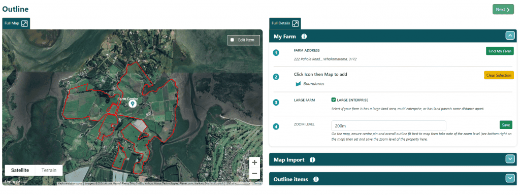
It’s possible to draw a “rough” boundary and then use the “Edit Item” checkbox on the map to refine the shape.
Once the boundary has been drawn (rough or fine) use the Zoom function on the map to work out what is best to show the entire farm on the map. Now use the Farm Centre icon to put a pin in the approximate centre of the farm.
Set the Zoom level to the same as what is displayed on the footer of the map.
Additional Functions:
Find My Farm – if you are unsure how to find your farm, the system can locate it using the address.
Large Farm – where farms are very large (several hundred hectares or more), or multi enterprise, it is possible to use the “Large Farm” function. This allows the map to zoom into certain parts at a time instead of showing the entire farm from a very high altitude
Outline Items – if multiple boundaries exist, which are not completely separate, use the checkbox “IS THIS THE WHOLE FARM OUTLINE?” to mark which outline is the main outline (this is very rare)
Map Import:
The QCONZ FWFP tool has inbuilt functionality allowing the import of .kml file types. This is achieved by using the Import Files button on the right side (top) to upload a file. Once uploaded the contents of the file are displayed in a list underneath on the right side in section SHAPES LIST.
Items are categorised as per what may have existed from the source file and displayed on the map.
De-select any items that you don’t wish to import (at this step it is possible to do multiple imports) then click SAVE.
The system will prompt with a summary of the items selected to import and the choice of where in the system to import them to.
Only matching “types” can be imported for items e.g. Land Units are “shapes” so only a shape can be imported as a Land unit. Similarly, a waterway is a line, so can only import a line.
NOTE: Importing maps for properties with multiple layers, or non-contiguous land units, can be quite involved. In these cases, it is worthwhile preparing a plan, doing several separate imports, and checking the various pages. QCONZ Support can help with importing (usual hourly rates apply).