CCCV
Ensure the catchment info displayed is the correct catchment for the farm.
Review the water test results and location from the map and table.
Complete and comment in the sections and fields for:
• Catchment Information
• Freshwater Values, Priorities, or Outcomes
• Sub Catchment Membership and Information
Supporting Documents – if there are any documents that may add additional information, use the document upload function. Enter a date and basic description and upload an attachment.
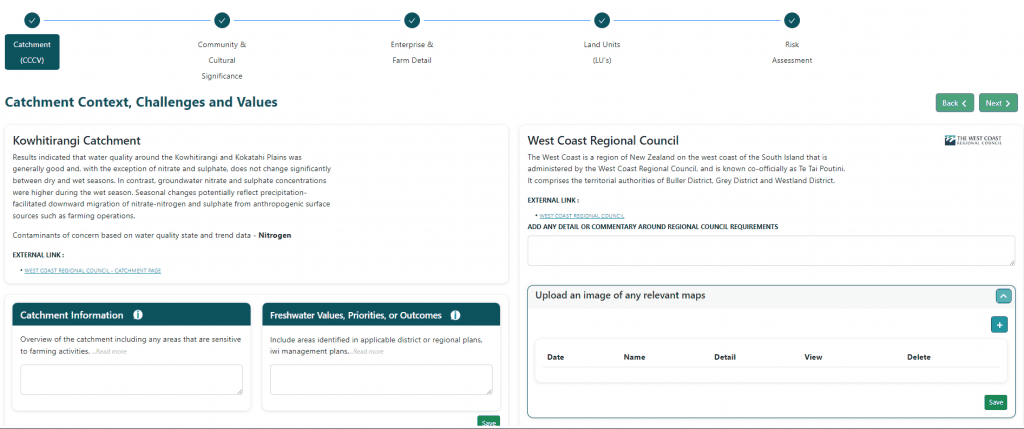
At the bottom of this page the system will display your farm and find the nearest LAWA water test points. The latest results for those test points will also display. These may be helpful to your plan build by informing you of water quality issues relevant to your district. If the test point(s) appear irrelevant to your farm just tick the Not Relevant Box
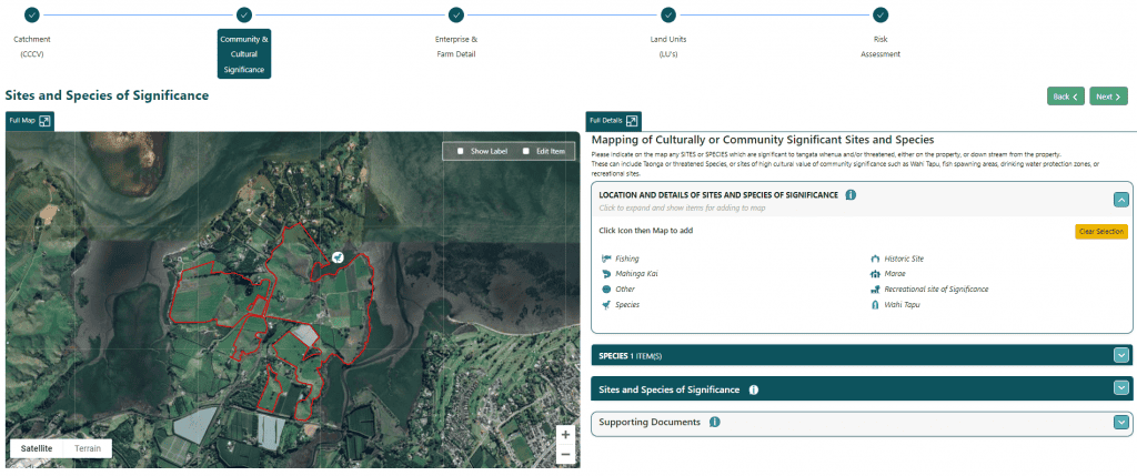
COMMUNITY AND CULTURAL SIGNIFICANCE
Complete the 2x Sites and Species of Significance questions. If you answer Yes to either (or both) of these two questions the system will create potential risks for you to address later in the build. Answering No to each question means no further action will be required for your plan build.
In the box “LOCATION AND DETAILS OF SITES AND SPECIES OF SIGNIFICANCE”, click an icon, then click on the map to place the icon in the correct location. Once placed the system will ask for Name and Description.
Once an item has been placed, it shows in the right-side pane underneath the box containing the icons (If you added a Species icon then this will show in the box titled Species).
Expand out a heading to see the actual item.
Hovering over the GPS icon will force the icon on the map to bounce (to locate the item if the map is cluttered or if you’re not sure where it is)
Supporting Documents – if there are any documents which may add additional information use the document upload function. Enter a date and basic description and upload an attachment.
ENTERPRISE AND FARM DETAIL
For the section Enterprises & Farming Activities click the “+” icon to add a record. At least one enterprise must be added for the property.
NOTE: For multi-enterprise farms (such as Sheep and Beef) it is recommended to create 2 X separate enterprises – 1 for Sheep and 1 for Beef. Further along, when mapping Land Units against what farming enterprise(s) are being done on that land unit, it may be desirable to differentiate between a land unit which is being farmed for one enterprise but not another.
Choose Category then Enterprise, then a brief Enterprise Type (up to 20 characters).
Use the field Enterprise / Farming Activities Description to provide more detail around the farming enterprise, and what type of farming and activities are performed on the property.
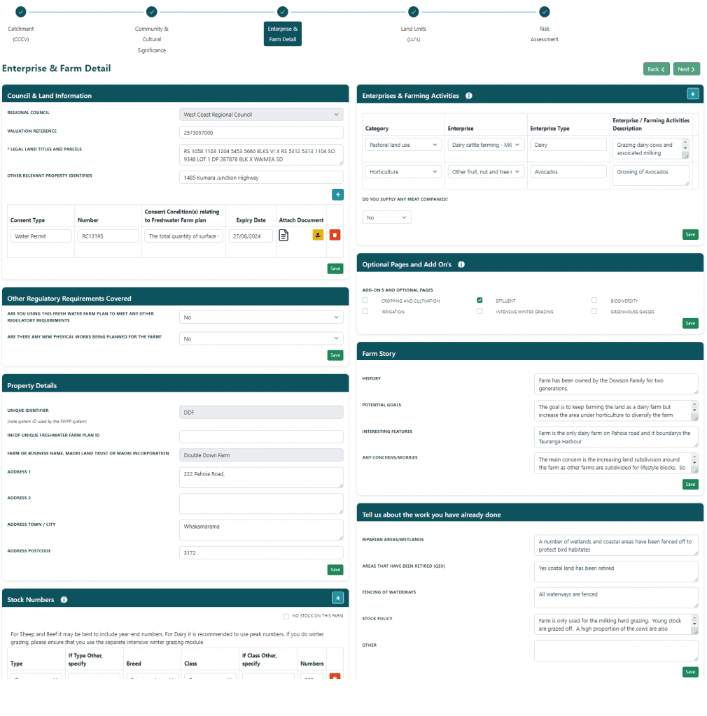
Section Optional Pages and Add On’s allows additional optional pages to be included in the Fresh Water Farm Plan.
CROPPING AND CULTIVATION – if needed to track crop areas and cropping records (Note: this is very basic currently just a starting concept)
EFFLUENT – for Dairy Milking Platforms
BIODIVERSITY – summarises and maps items which have been “flagged” as representing Biodiversity.
IRRIGATION – if irrigation is in place, use this page to outline systems and irrigated areas (Note: improvements coming soon)
INTENSIVE WINTER GRAZING – build and display the winter grazing plan (COMING SOON)
GREENHOUSE GASSES – a basic starting page to create GHG related actions.
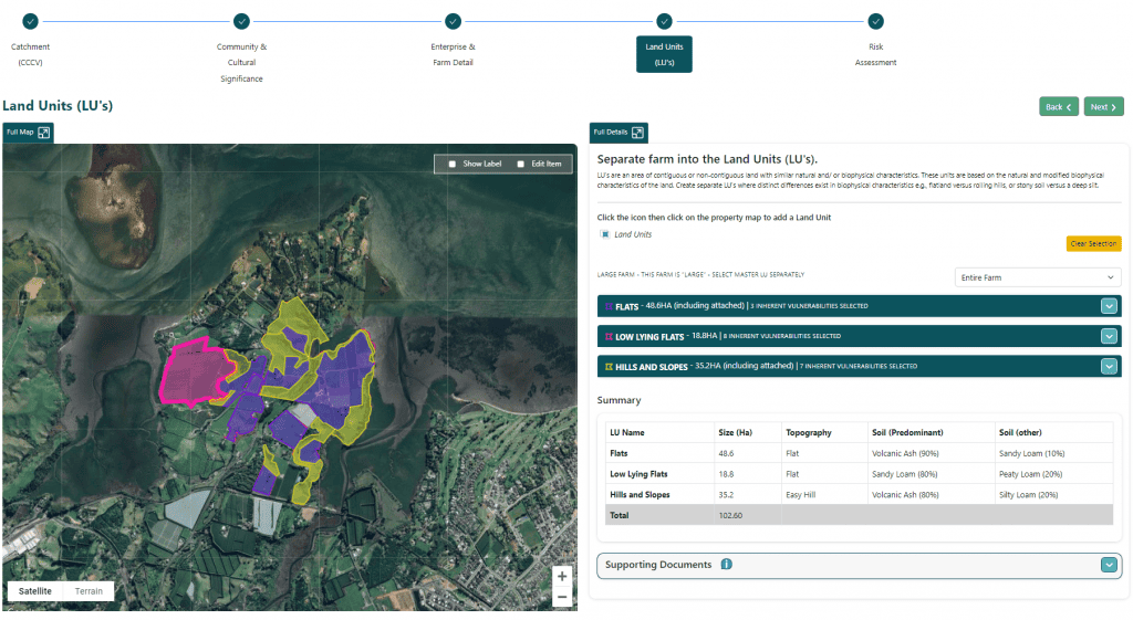
LAND UNITS
On this page the system is used to separate the farm into Land Units. Click the icon then click on the farm map to
add an LU – click the Boundary icon and draw an LU.
Once the drawing of the shape has been completed and “joined” the system will pop up a box asking for the details
about the LU.
- Name and Description
- Set colour
- Inherent Vulnerability(s) – expand and select what inherent vulnerabilities exist on this land unit
- Additional Information – expand to enter soil, drainage, and other basic detail
- Enterprises / Farming Activities – expand and select what farming enterprises are performed on this LU, or
for Land Units not farmed (eg. Native Bush) select “This LU does not have any Farming or Growing activities” - Further Detail – expand to enter additional detail “Pasture & Drainage” (only if using for Nutrient input
purposes) and “Advanced Soil Details” if known
NOTE: It is possible to draw a “rough” LU shape first then use the “Edit Item” checkbox on the map to then refine the
shape.
Non-contiguous Land Units
It is possible to “join” multiple shapes into a single land unit. This may be where separate shapes on different areas within the property share the same soil and physical characteristics.
To activate when editing an LU, select “Non-contiguous” and choose the LU this one will be connected to. From that point the LU is now a “child”.
Once a “child” LU has been joined to the “Parent” for the various other information and details needed it is possible to keep the detail separate, or more commonly, the child LU will also select the option “Same as Master”. This will ensure the child LU does not need to have colour or other detail specified.
When an LU has “children” an additional option shows when you expand the LU container for “Child LU display” – option “Map Only” shows the LU and children on the map but does not list children in the table data on right side.
Option “Map & Table” expands the table data on right side to see list of child LU’s.
Note: for an LU to be a “parent / master” there is no additional setting needed.
Large Farms
Where Large Farm has been ticked in the Outline page, it is possible to add a Centre Pin and default Zoom for each Land Unit. Expand the LU “container” on the right side to view the base LU detail and access the settings.
Use function “View this block only” to only show the selected LU (note this has same function as field “LARGE FARM – THIS FARM IS “LARGE” – SELECT MASTER LU SEPARATELY” which is shown above the list of Land Units.
Land Units Summary
Under the Land Unit list, a summary totals the sizes and effective areas for the Land Units together.
Photos:
When editing a Land Unit, it’s possible to upload any number of photo(s) of the land unit.
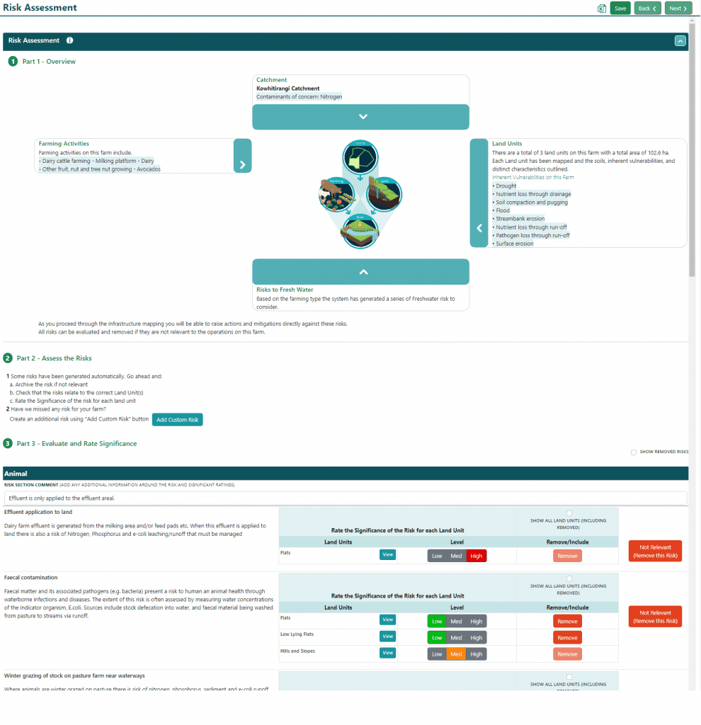
RISK ASSESSMENT
The Fresh Water Farm Plan system automatically creates a set of Farming Activity risks based on what Enterprises
have been selected. These have been created based on our understanding of farming systems and MfE requirements
from the Fresh Water Farm Plan development document (June 2023). On this page you will review these risks ie are
they relevant to the land units they’ve been created against, and if they are, to what level of significance (in your
opinion). Irrelevant risks from be removed. If you change your mind at any stage, they can be added back again later
by ticking the Show Removed Risks box and selecting which risk you want to include. If a relevant risk is not showing
you can create your own custom risk by hitting the Add Risk button.
RISKS
The system draws from an extensive pre-selected list which includes the following:
- 12 Risks specific to Pastoral
- 9 Risks specific to Horticulture and Arable
- 2 Risks specific to Deer
- 2 Risks specific to Dairy
- 5 default risks for ALL farms
- 3 “custom” risks for specific situations including Winter Grazing, Irrigation, and Frost Protections
- 2 Catchment Risks (triggered from Yes/No questions in Community and Cultural Significance)
For each Risk some additional information is also shown including Farming Activity(s) (which enterprise triggered the
risk) and the Contaminants that each risk has been associated with. Click the View button to see this detail.
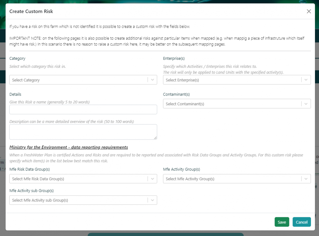
CUSTOM RISKS
Users can create a new risk if needed. After clicking the ADD NEW button the user will need to enter all the
information required to create the risk, including MfE data categorisation (risk and activity groups).
- Category, Name & Description
- Enterprises (used to select which LU’s to apply the risk to)
- Contaminants
- MfE data categorisation (note these drop-down selections)
EXPORT TO EXCEL
Export to excel
- If there is an extensive list of Risks and Land Units it may be better to review/view in excel