Southland Maps Link
https://gis.southlanddc.govt.nz/ViewerExt/?map=14f14c29e43f409a82238e7cc5a4fa3b
Otago Maps Link
https://maps.orc.govt.nz/OtagoViewer232/?map=6e824aab1adb4cbe9fcbabec9cac4127#
Waikato Maps Link
https://waikatomaps.waikatoregion.govt.nz/Viewer/?map=57b2b09738a84292acf9b7d09f02ec7e
Hawkes Bay Maps Link
https://gis.hbrc.govt.nz/LocalMapsViewer/?map=5132e0ccd5204228b209f0bec472ded7
Greater Wellington Maps Link (Only Wellington City)
https://gis.wcc.govt.nz/LocalMapsViewer/?map=95a0685dff724fc19035abd59c630b14
Horizons Map Link
https://maps.horizons.govt.nz/Viewer/?map=db6220b04c424927b25b77f1727413ca
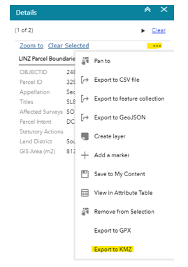
To export maps from any of these Regional councils, click the property area you wish to export a boundary of and then click the 3 dots of the right-hand sidebar.
This should open the export options, form here click “Export to KMZ”
Once you have the KMZ file downloaded, open it with Google Earth Pro (free software).
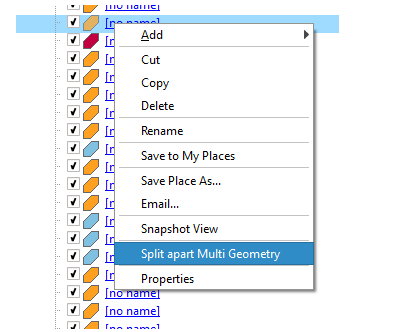
Right-click each map item; if the map item has the option “Split part Multi Geometry”
then you will need to click this.
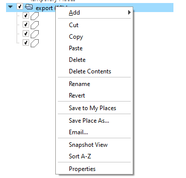
Once you have done this for all map items, right-click the folder that holds the map item(s) and select “Save place as..”
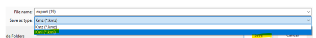
From here change the “Save as type:” to Kml and then click “Save”
This file should now be able to be imported into the QCONZ FWFP tool!